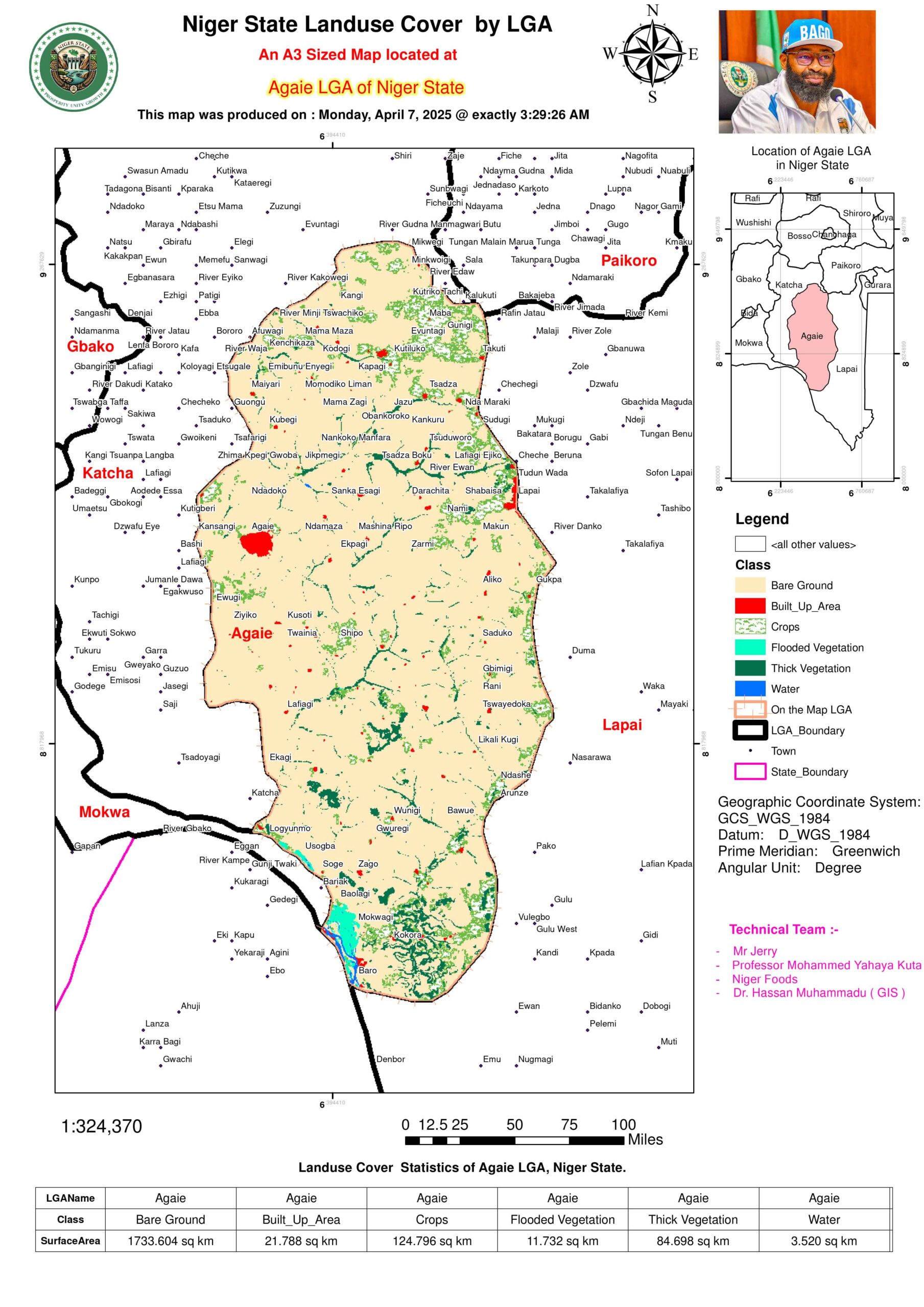
Landuse & Landcover PDF Maps
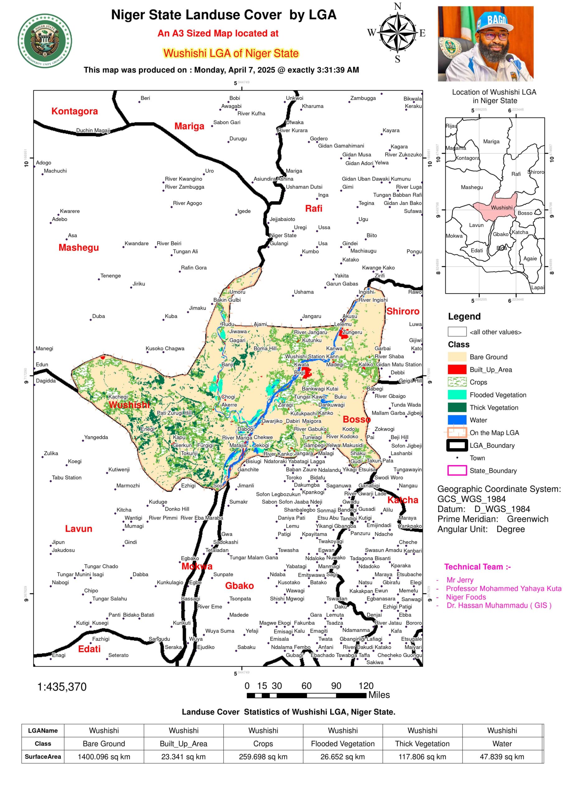
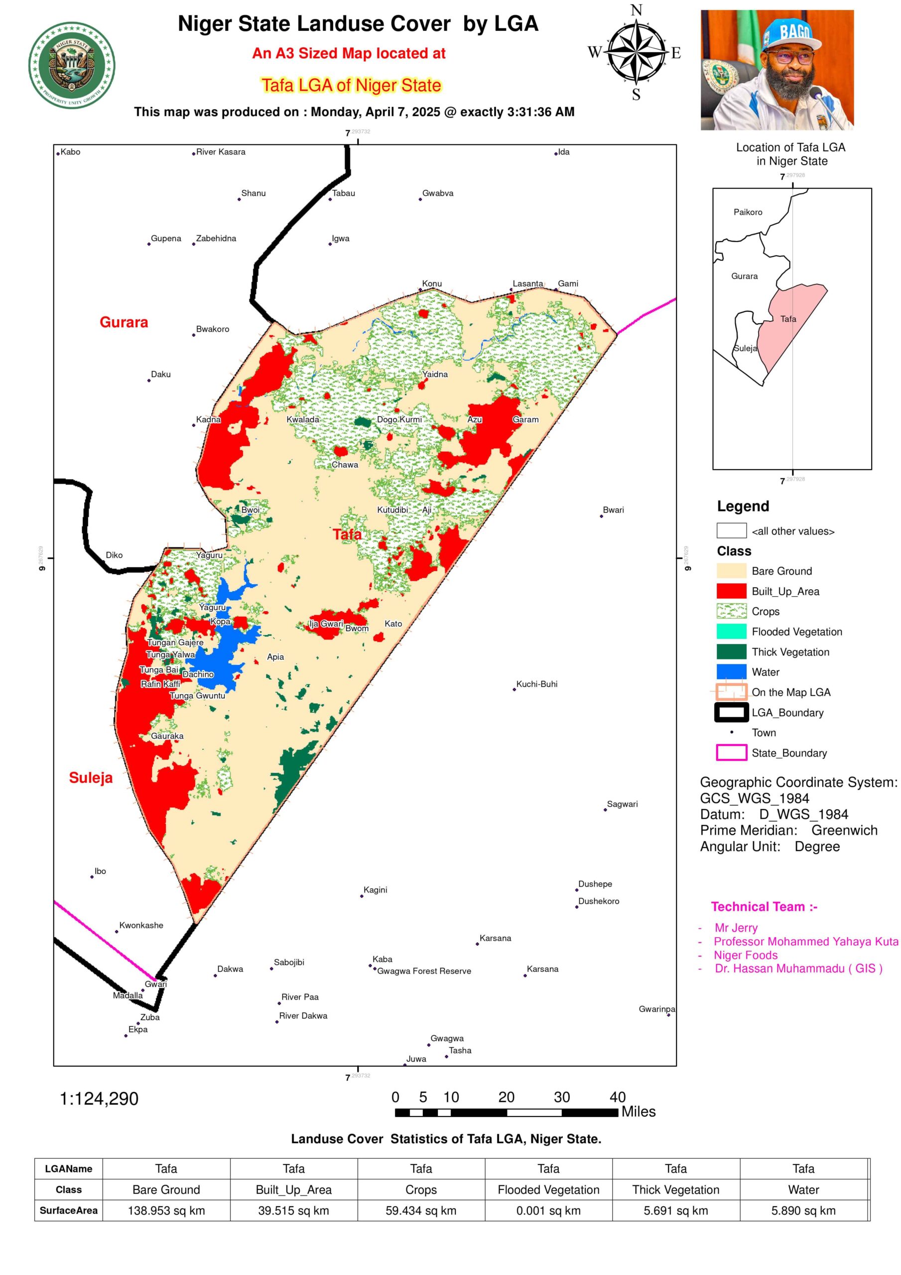
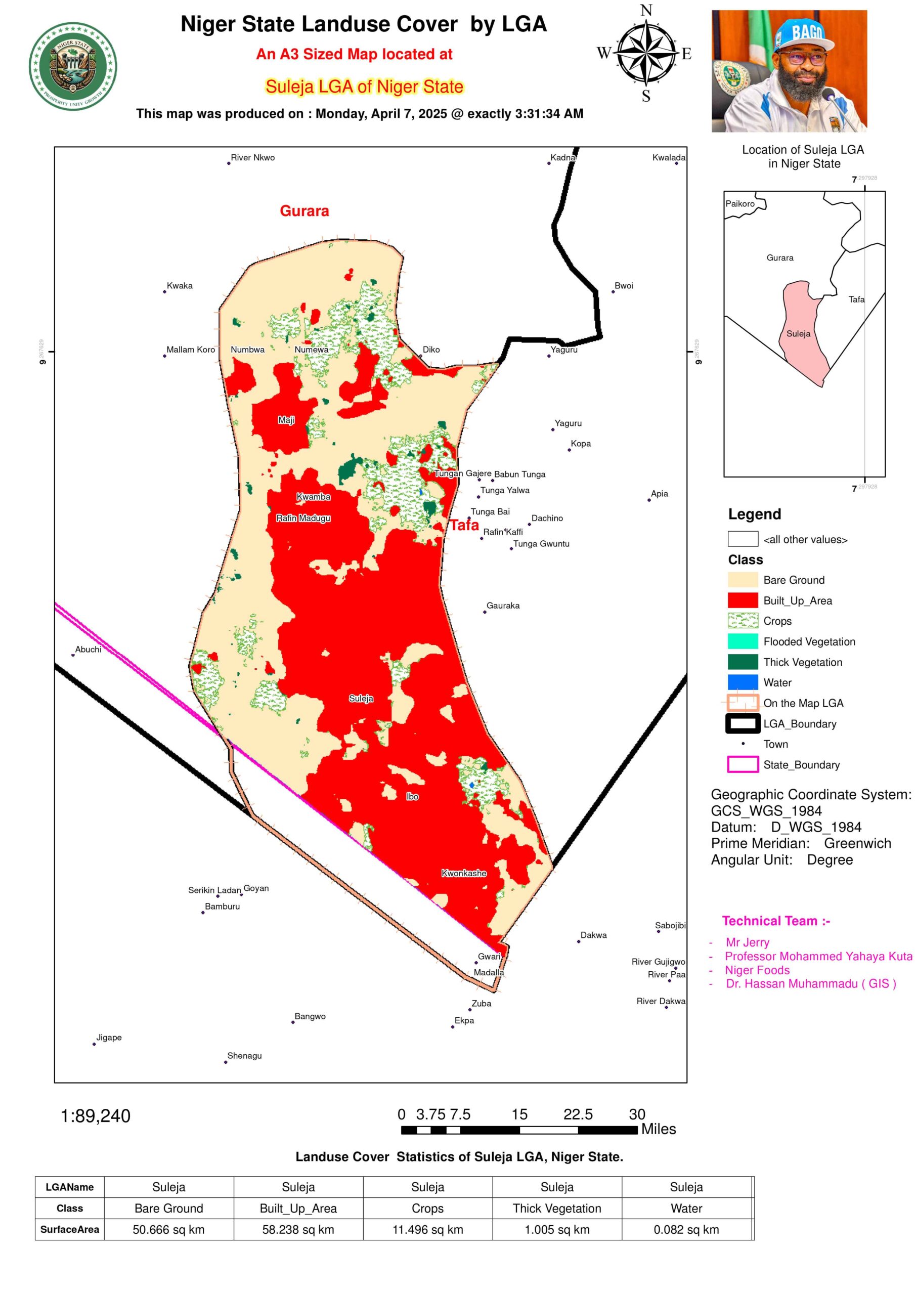
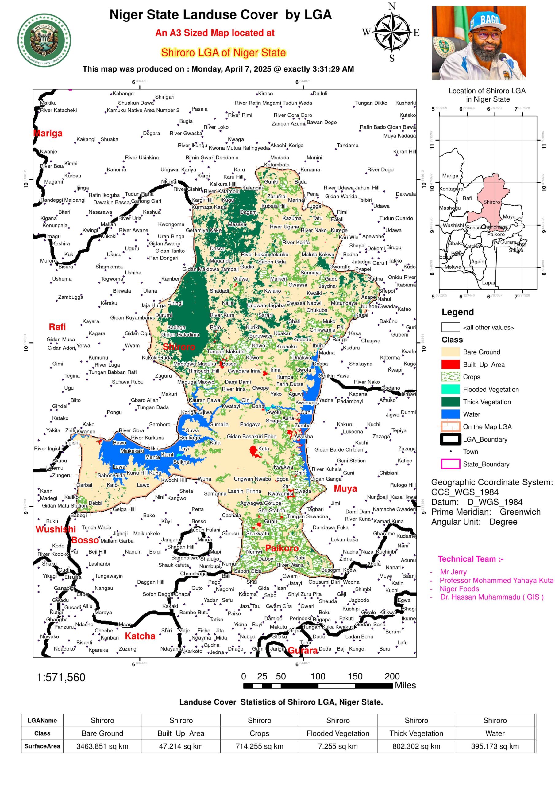
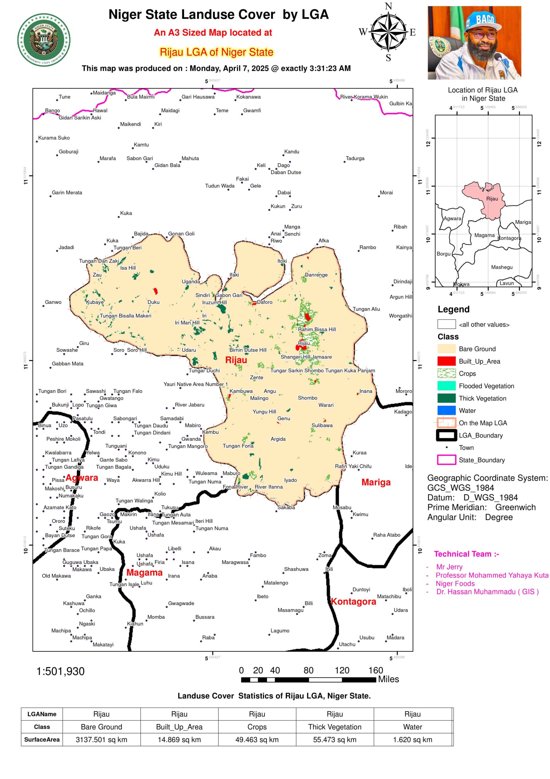
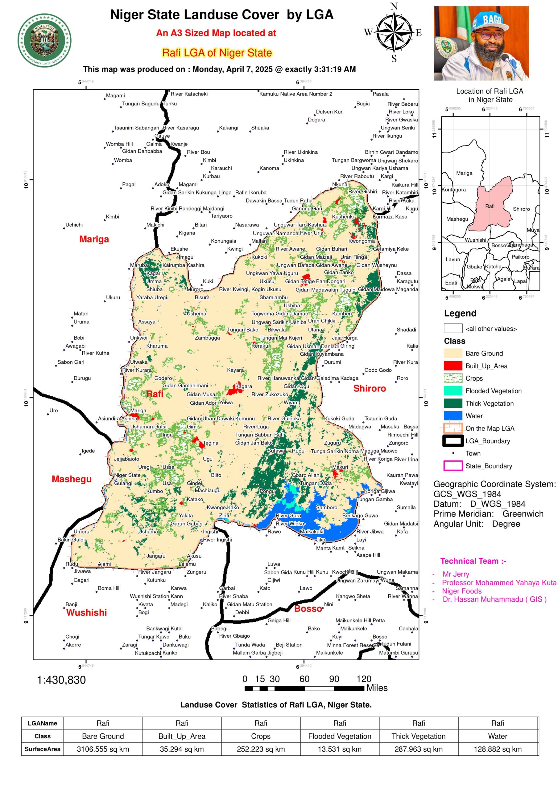
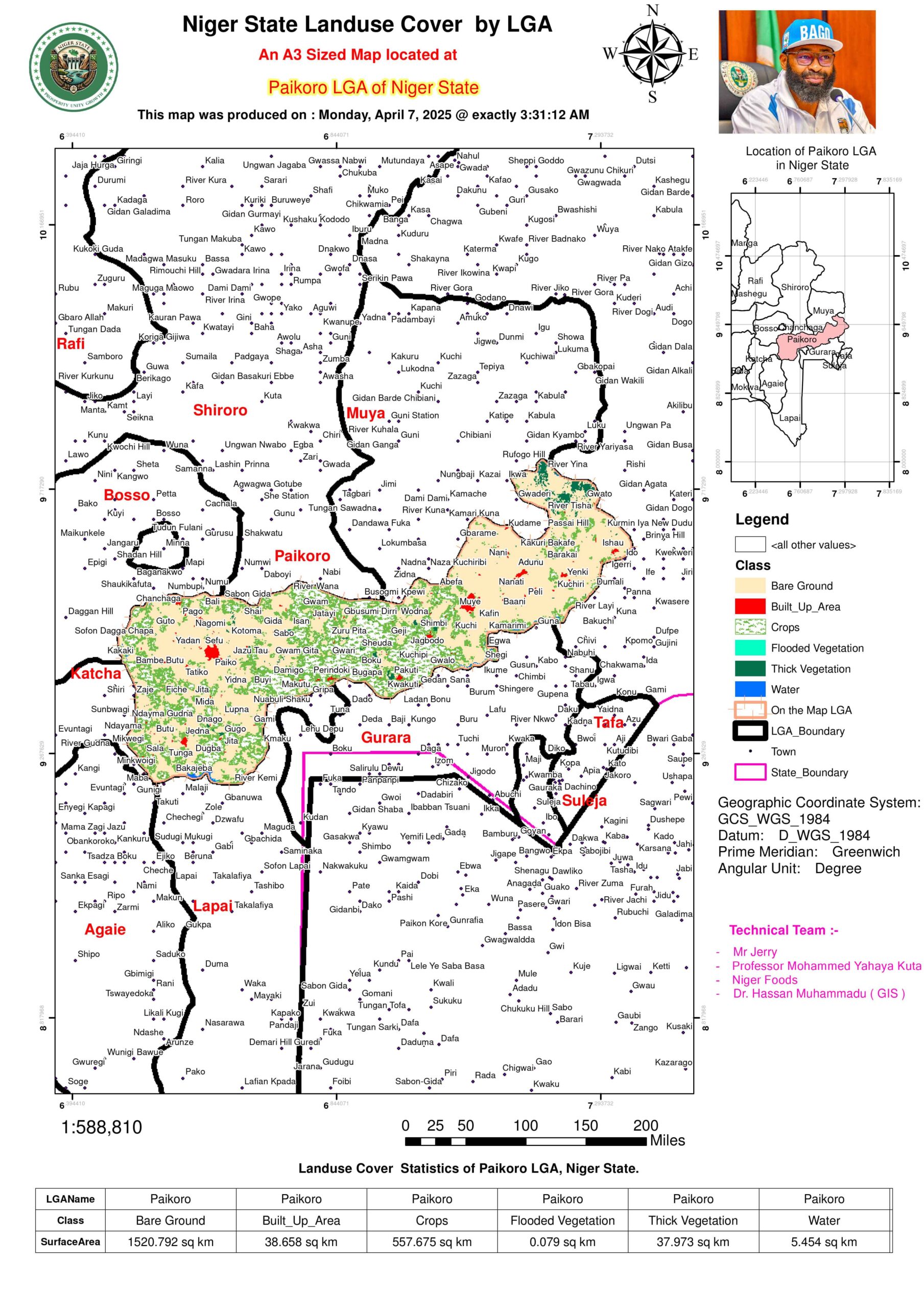
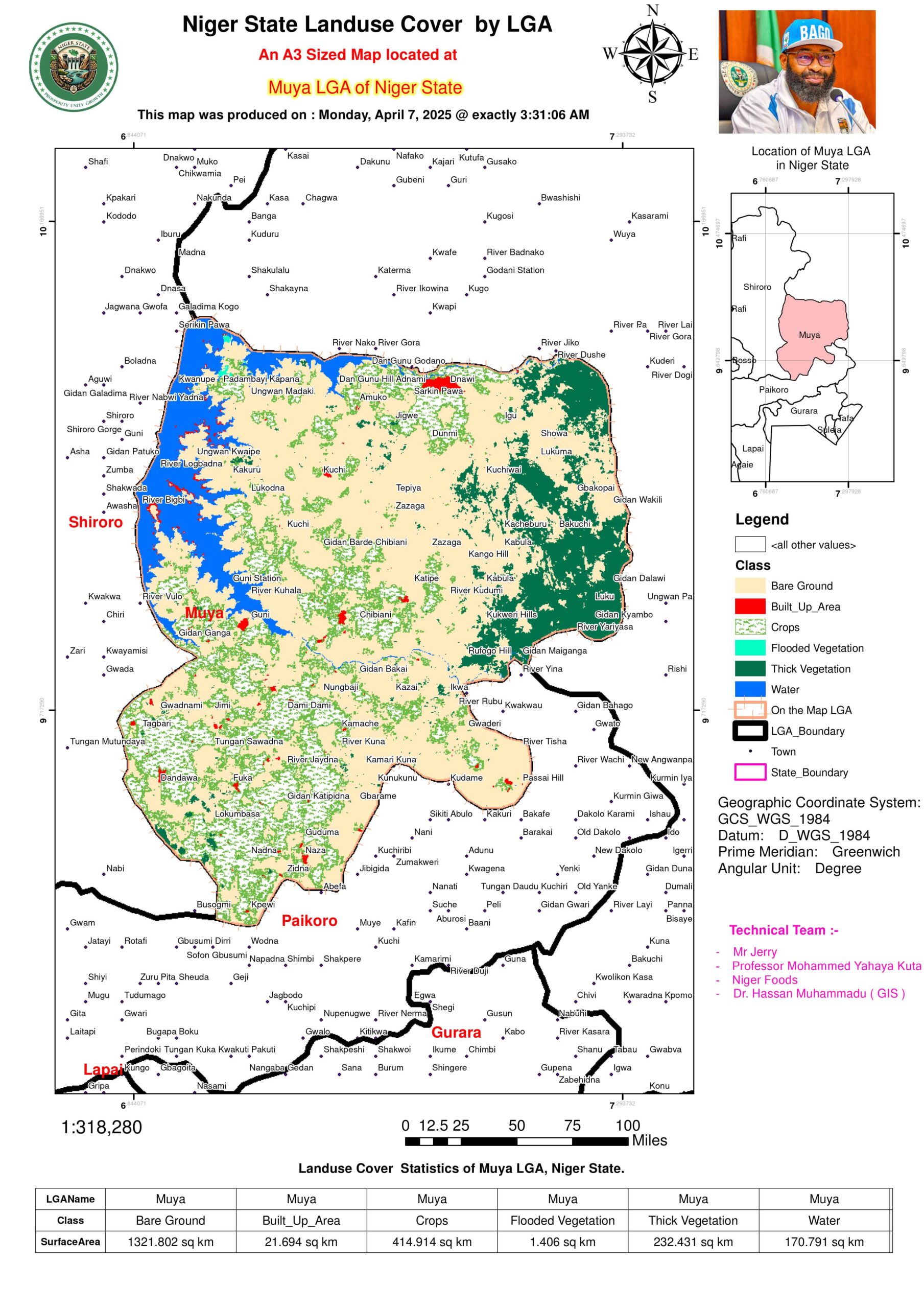
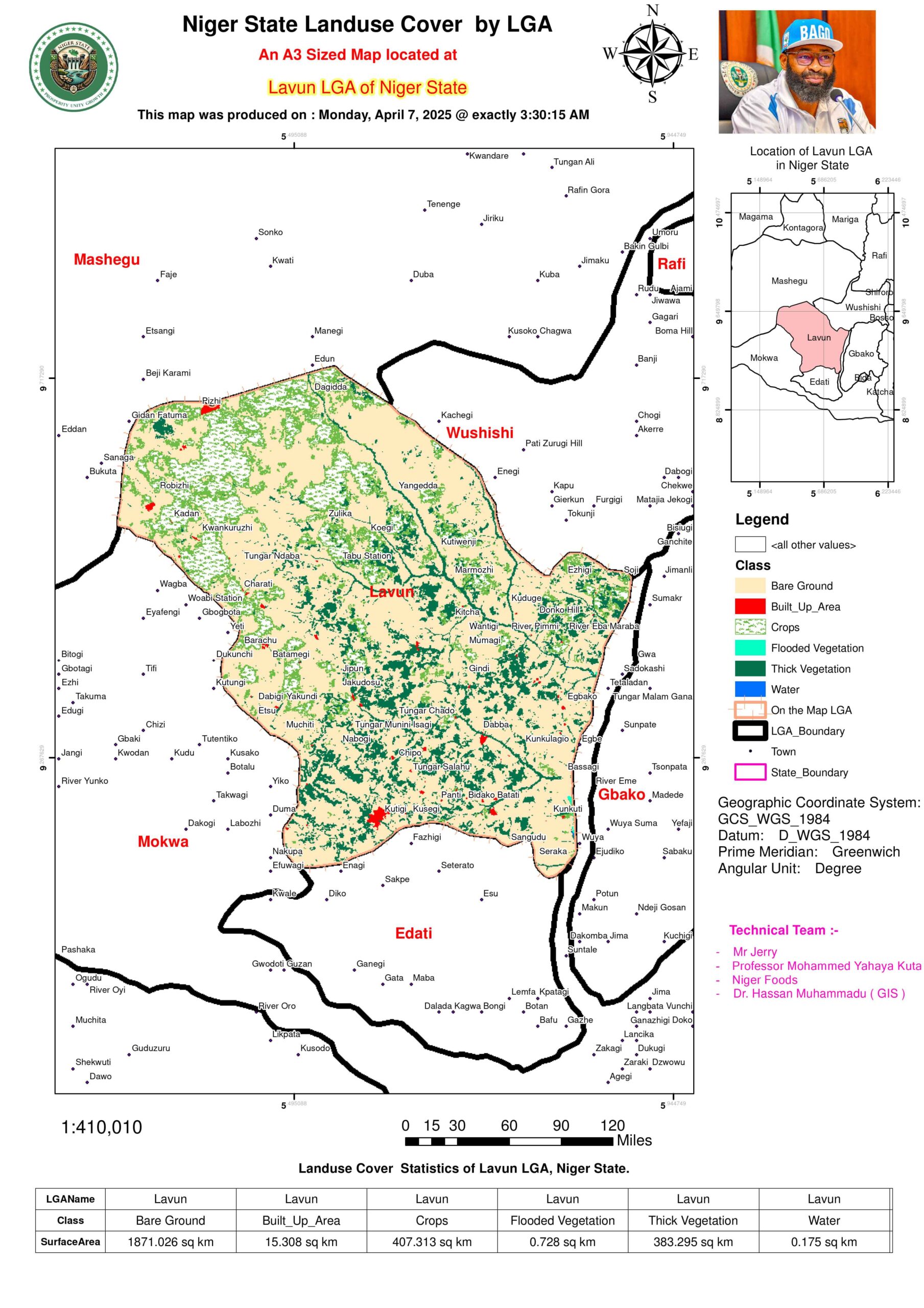
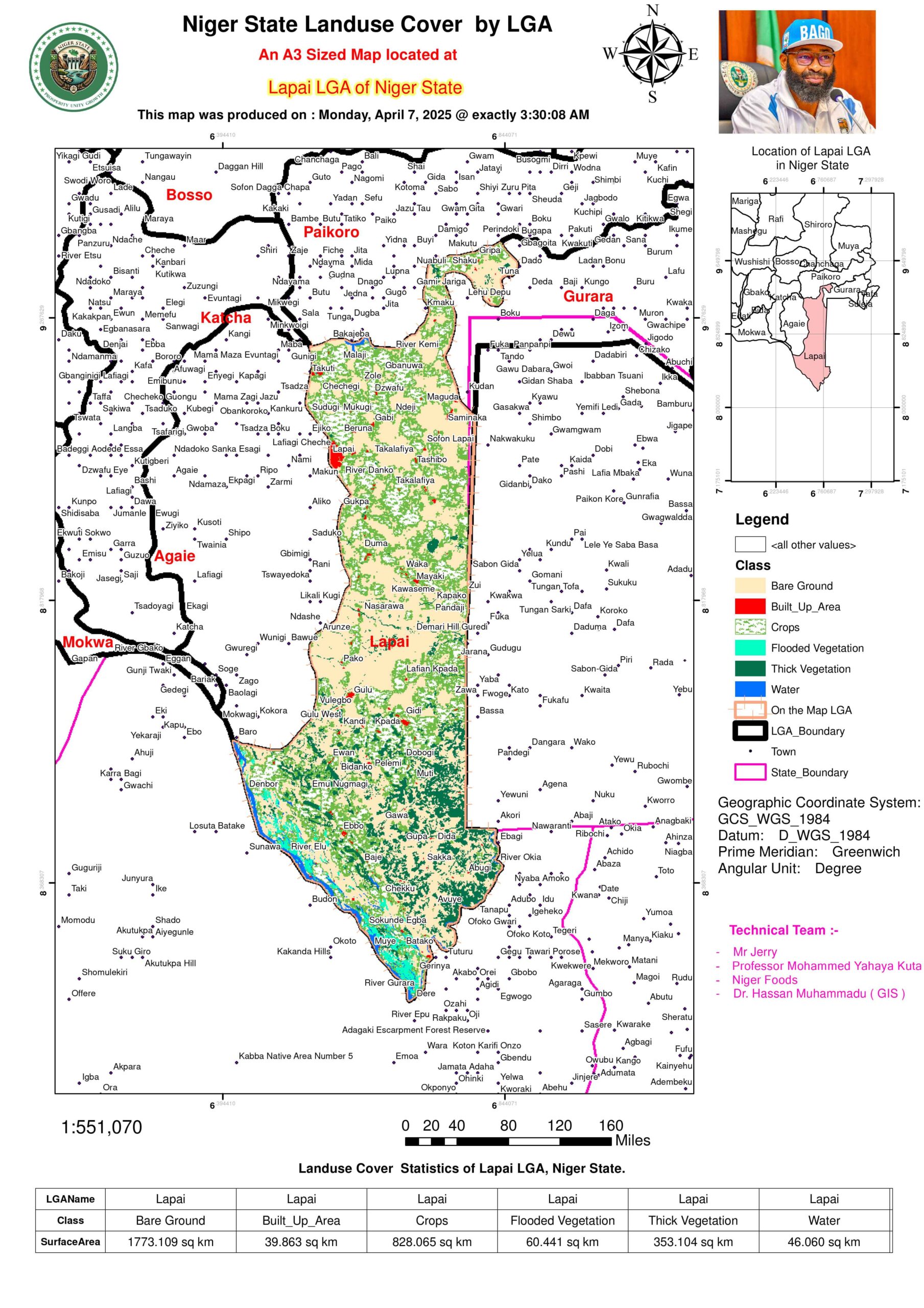
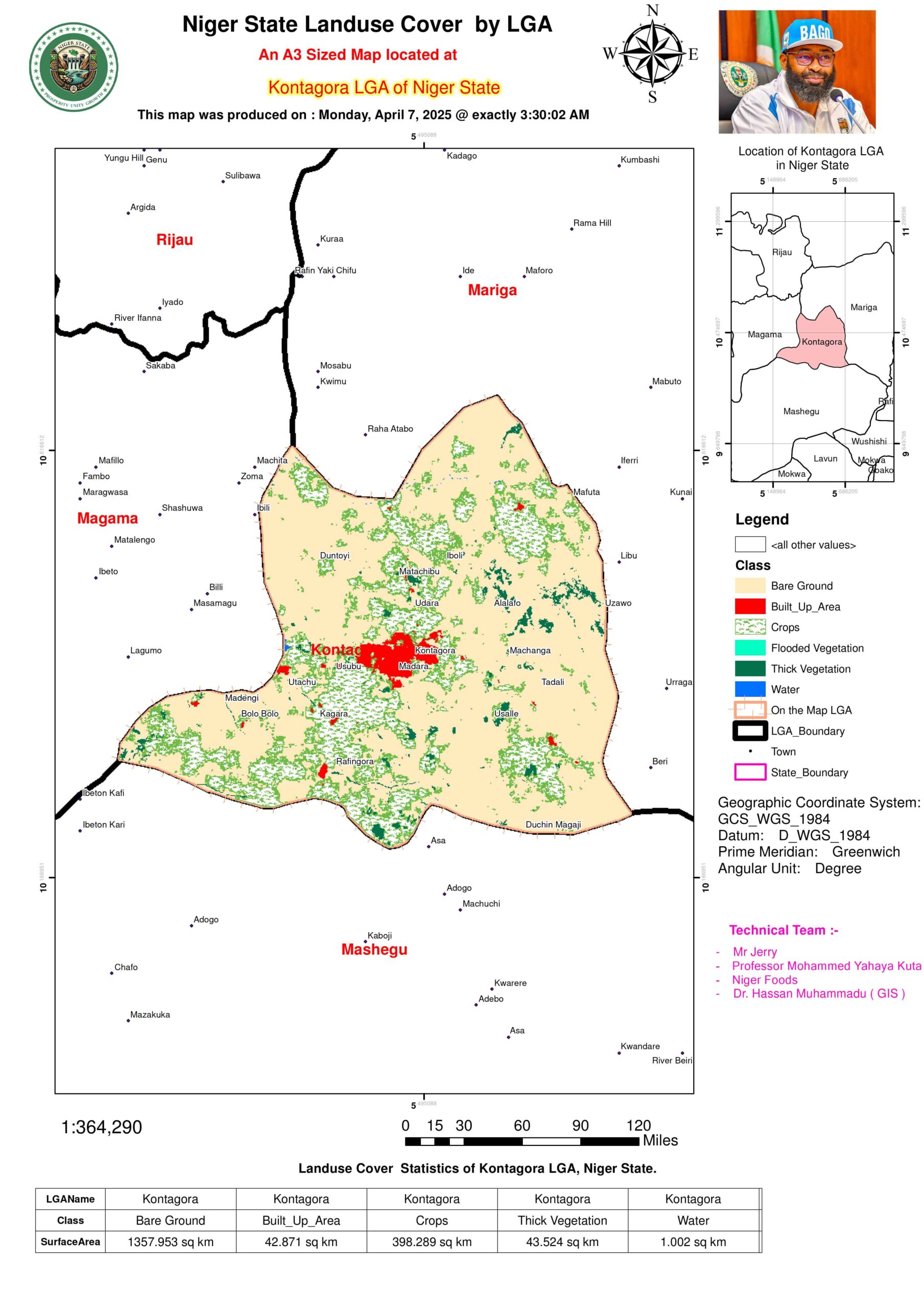
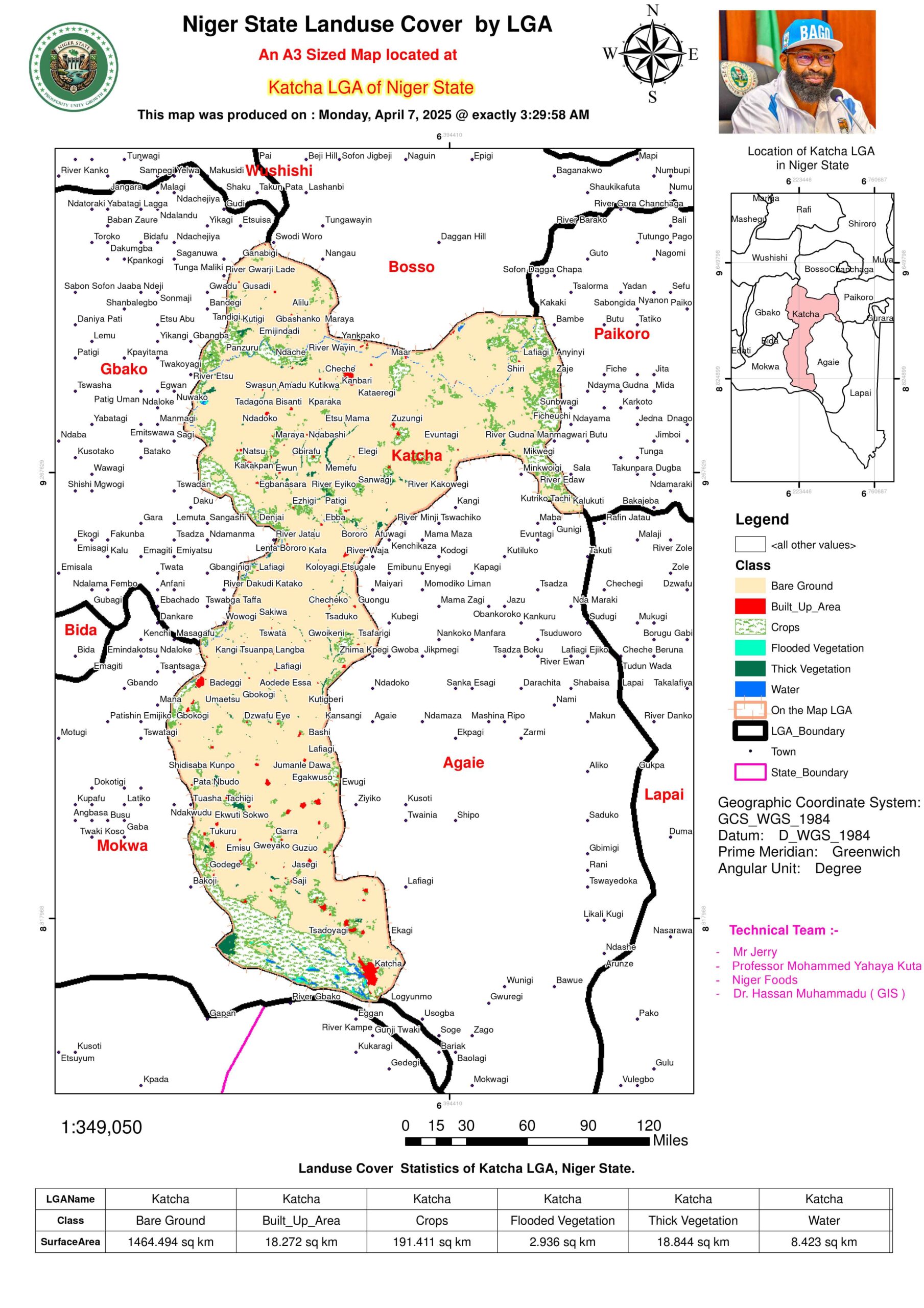
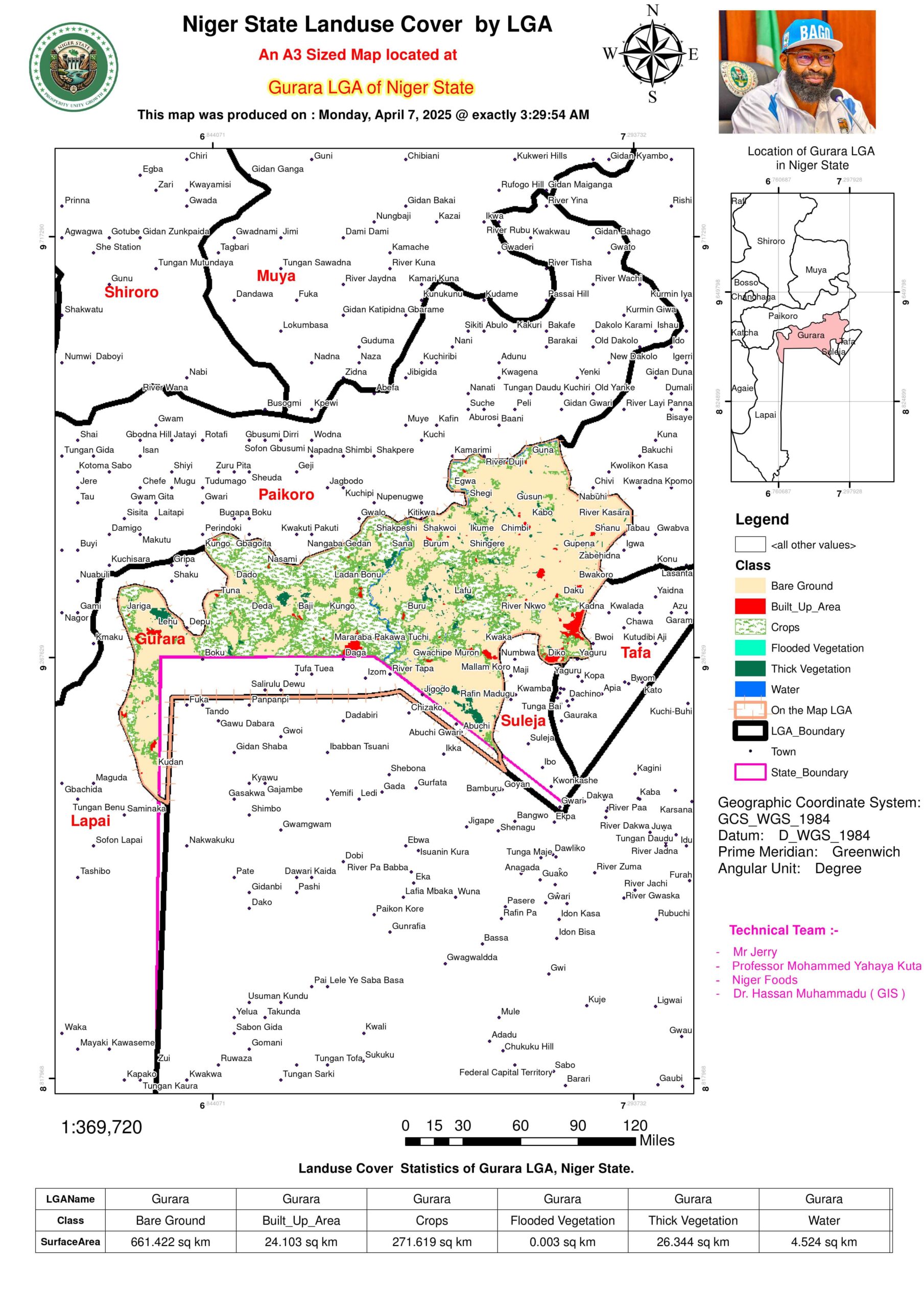
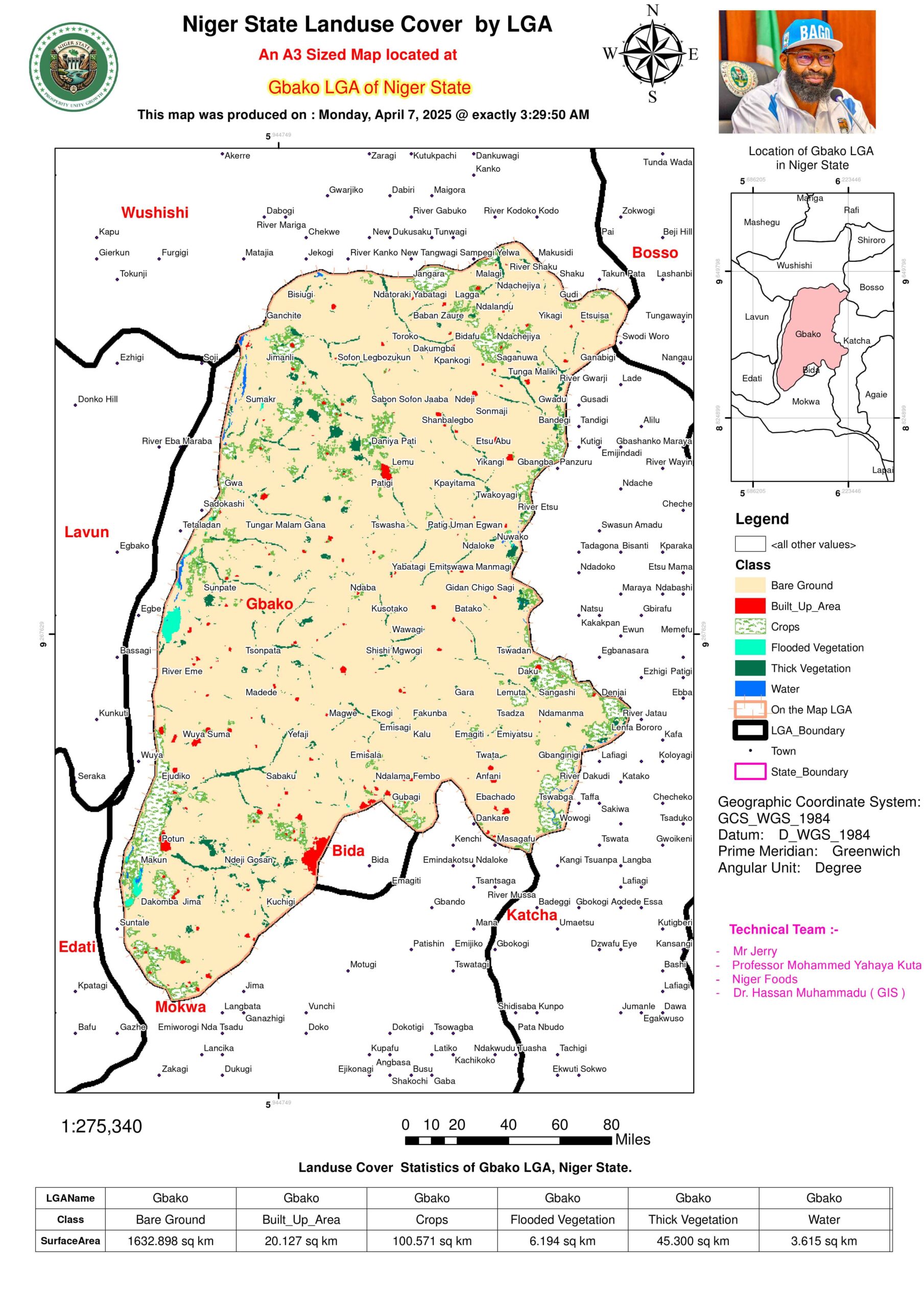
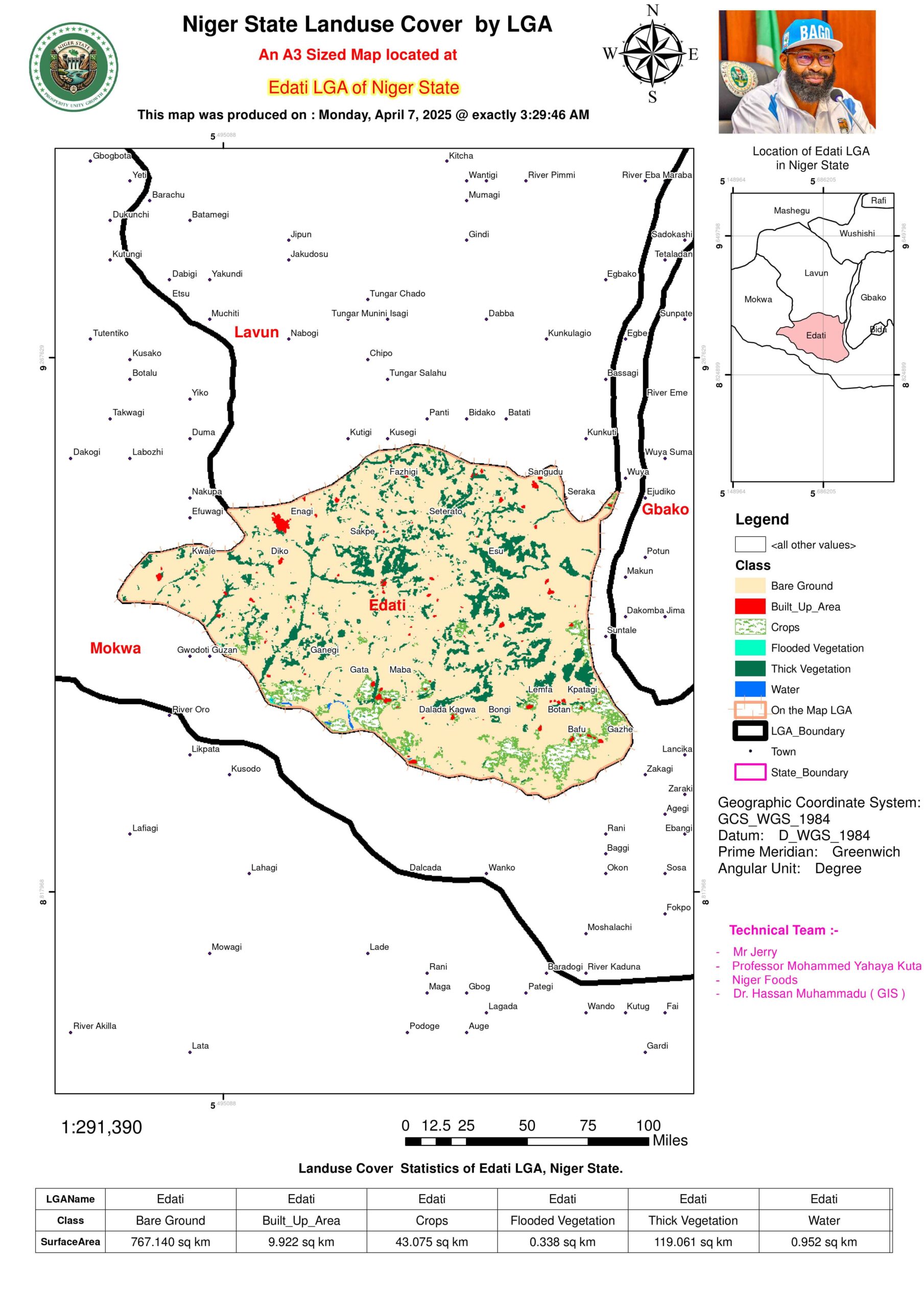
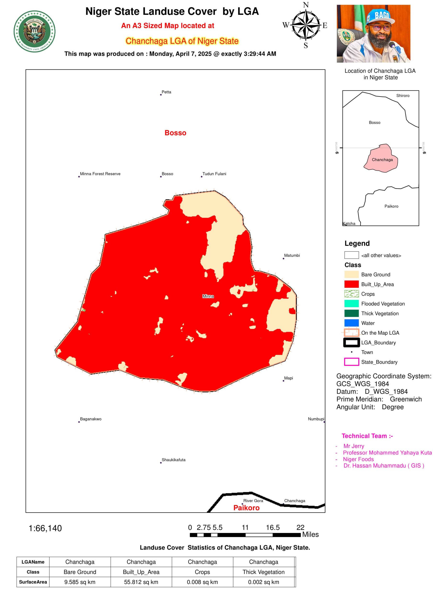
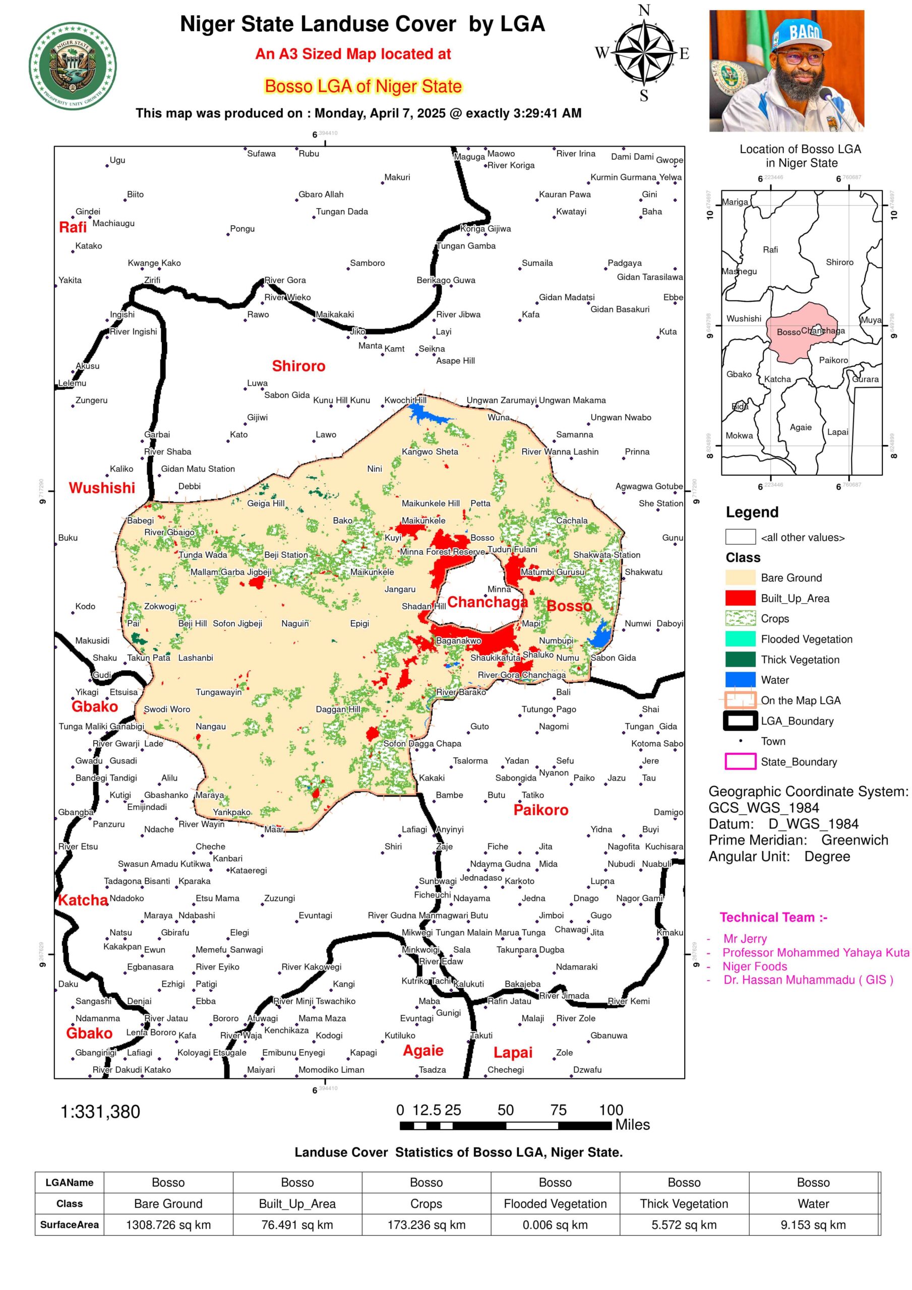
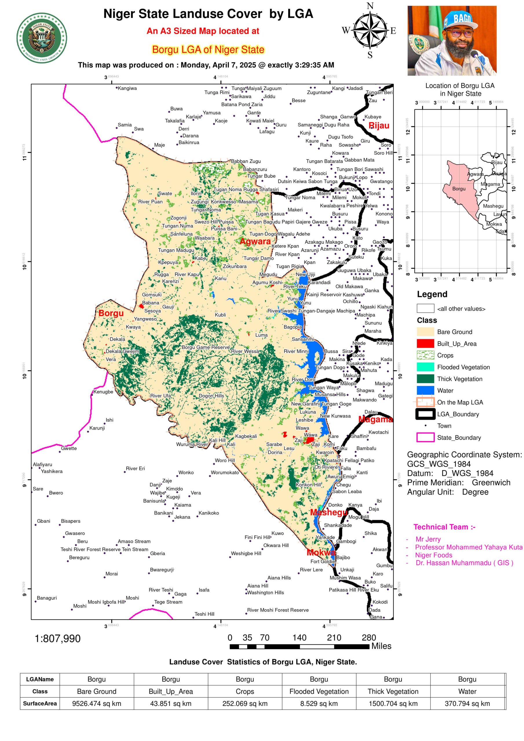
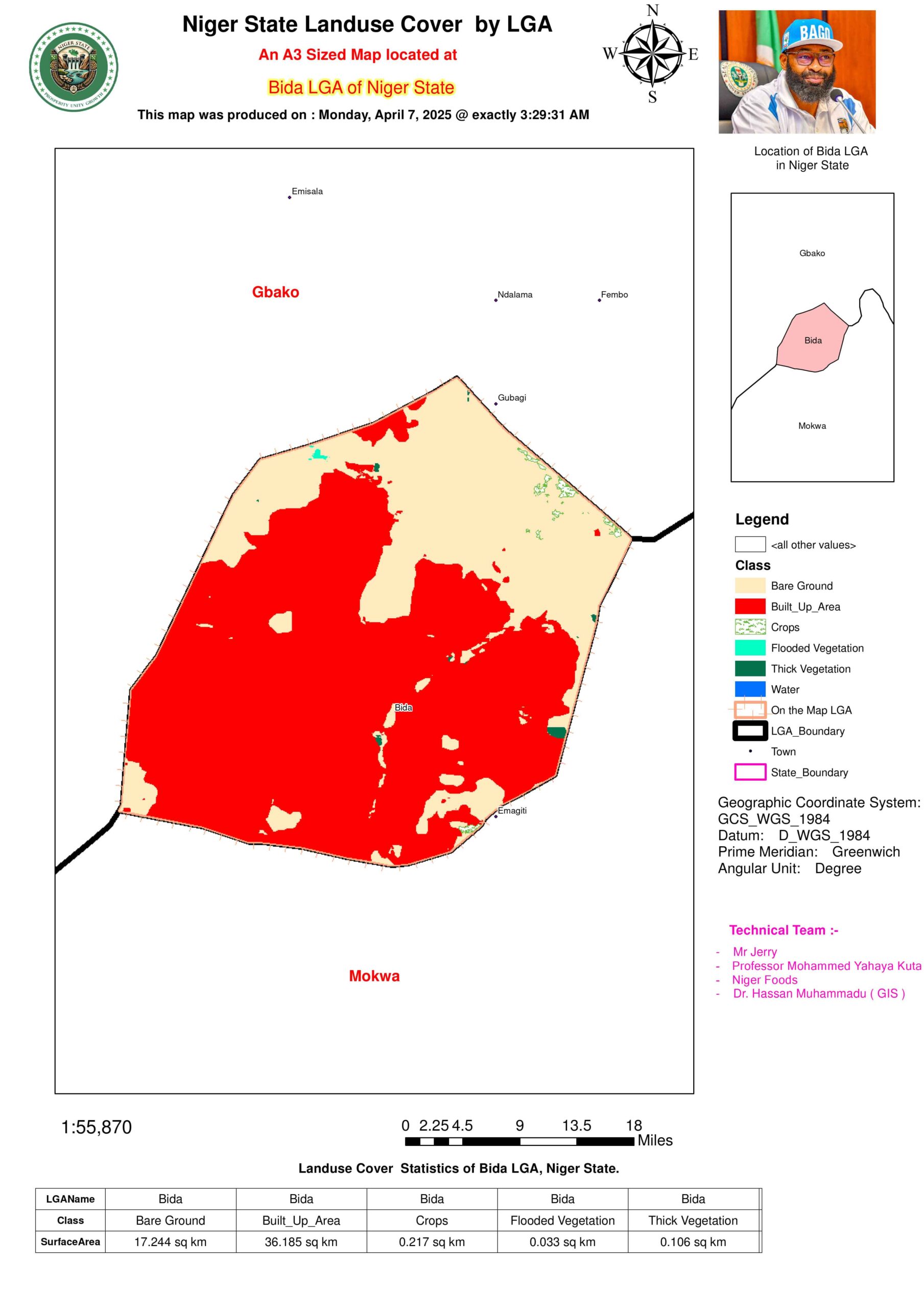
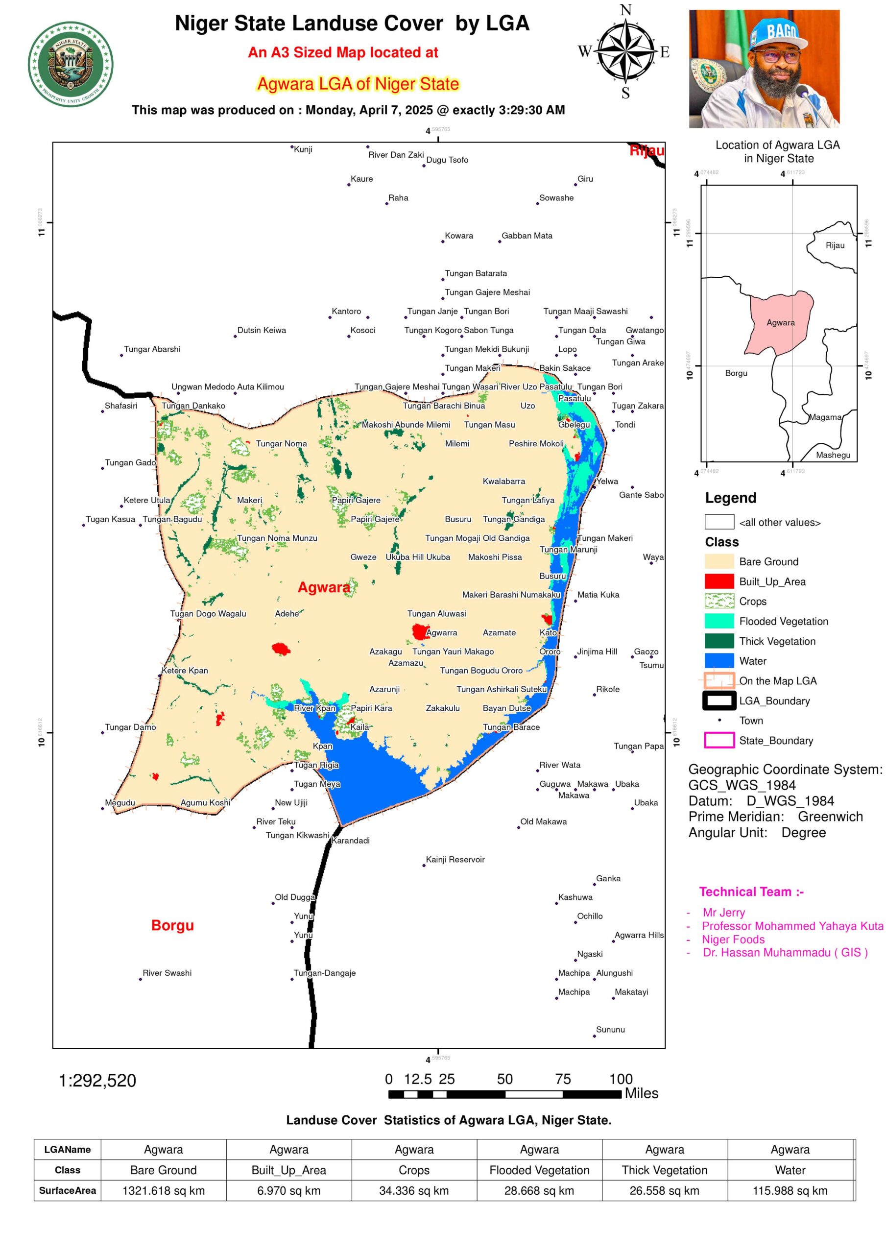
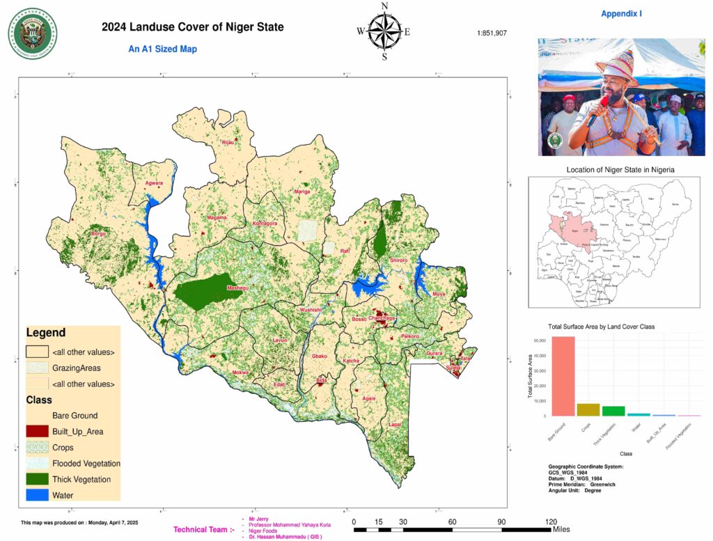
The provided dataset offers a meticulous geospatial breakdown of land cover classifications across multiple Local Government Areas (LGAs) in Nigeria, quantifying surface areas for categories such as Bare Ground, Built-Up Areas, Crops, Flooded Vegetation, Thick Vegetation, and Water. This analysis transcends mere tabulation, delving into the ecological, agricultural, and urban planning implications of these distributions. By synthesizing this data, we uncover patterns that reflect both natural biogeographical processes and anthropogenic influences, thereby illuminating pathways for sustainable development. See State map on Landuse and land cover below:-
2. Dominant Land Cover Patterns
2.1. Bare Ground: The Prevailing Feature
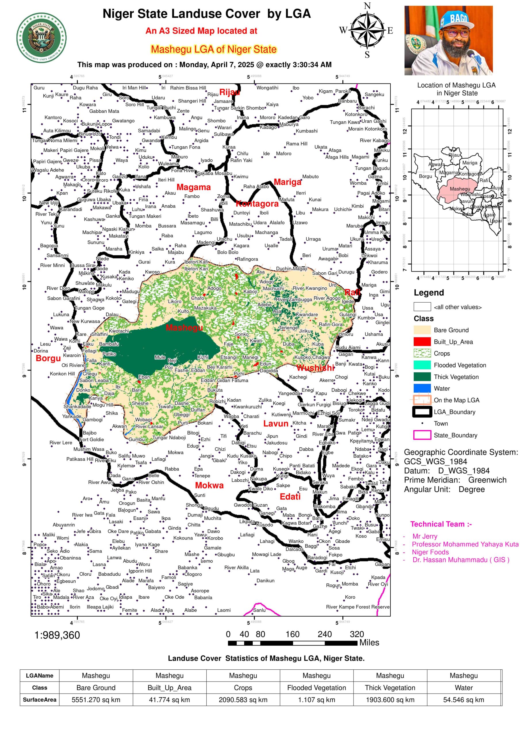
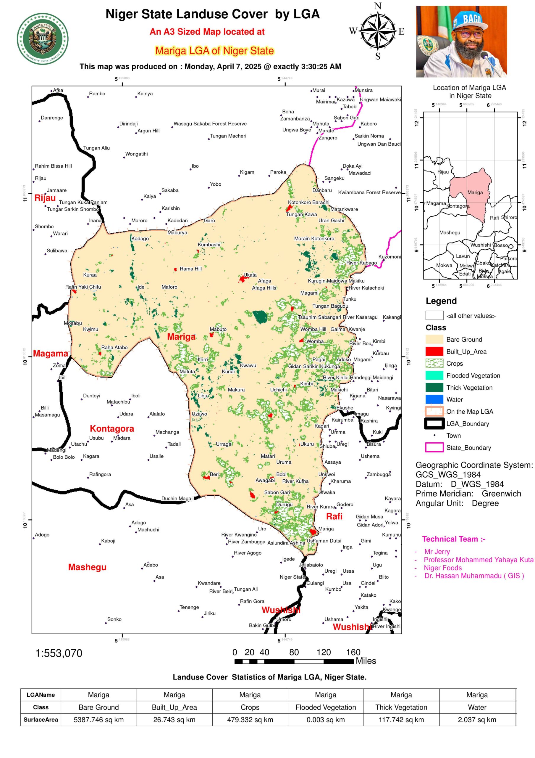
Magnitude: Bare ground is a dominant feature in several Local Government Areas (LGAs) across the region, notably in areas such as Mashegu (5,551.27 km²), Mariga (5,387.75 km²), and Borgu (9,526.47 km²). These extensive land areas suggest a landscape characterized by arid or semi-arid conditions, where vegetation is sparse, and the soil is largely exposed. The presence of bare ground across these LGAs indicates a significant environmental challenge, highlighting the need for careful land management and intervention.
Implications:
Ecological: The high prevalence of bare ground may signal the region’s vulnerability to desertification, particularly in northern LGAs like Borgu and Magama. Desertification occurs when land becomes increasingly barren due to factors such as overgrazing, deforestation, and climate change. In these areas, the natural processes of soil erosion are more pronounced, and the absence of vegetation exacerbates the issue, making it harder for soil to retain moisture and nutrients. If left unmanaged, desertification could further degrade the land, leading to reduced biodiversity, loss of ecosystem services, and a negative feedback loop that worsens environmental conditions.
Agricultural: The vast expanses of bare ground have significant consequences for agriculture, especially rain-fed farming. Without sufficient ground cover or organic matter, the soil’s ability to retain moisture is drastically reduced. This means that during the dry season, crops face increased stress, and the risk of crop failure is heightened. As a result, farming in these regions is less reliable, and productivity could be severely constrained, making it less viable for subsistence farming or even small-scale commercial agriculture. To address this issue, significant investments in irrigation infrastructure may be necessary to supplement rainfall and provide consistent water supply to agricultural activities.
Additionally, the limited vegetation cover means that natural processes like nitrogen fixation and soil enrichment through organic decomposition are also constrained. Therefore, it may be essential to introduce agroforestry or other soil improvement practices, including mulching and cover cropping, to help restore soil fertility and increase agricultural productivity over time.
2.2. Thick Vegetation: Biodiversity Hotspots
Key LGAs: Areas like Shiroro (802.30 km²), Mashegu (1,903.60 km²), and Lapai (353.10 km²) are characterized by dense vegetation cover, indicating the presence of rich and diverse ecosystems. These regions are home to a variety of plant and animal species, making them crucial for both biodiversity conservation and environmental health.
Significance: The dense vegetation in these LGAs serves several important ecological functions, including acting as carbon sinks—large areas of vegetation that absorb and store carbon dioxide, playing a critical role in mitigating climate change. In addition, these areas are likely vital wildlife habitats, providing shelter and food sources for numerous species, including rare and endangered ones.
The concentration of thick vegetation in Shiroro aligns with its proximity to forest reserves and the Niger River, both of which contribute to the area’s rich biodiversity. The forest reserves act as protected zones for wildlife, while the river provides a vital water source for both plants and animals. The Niger River also helps to regulate the local microclimate, maintaining the humidity levels necessary for sustaining dense vegetation. These areas also support indigenous species that depend on the specific environmental conditions found in these hotspots.
From an ecological perspective, these areas are critical for conservation efforts and could serve as models for sustainable environmental management practices, including eco-tourism, that can provide economic benefits while preserving natural habitats.
2.3. Built-Up Areas: Urbanization Footprints
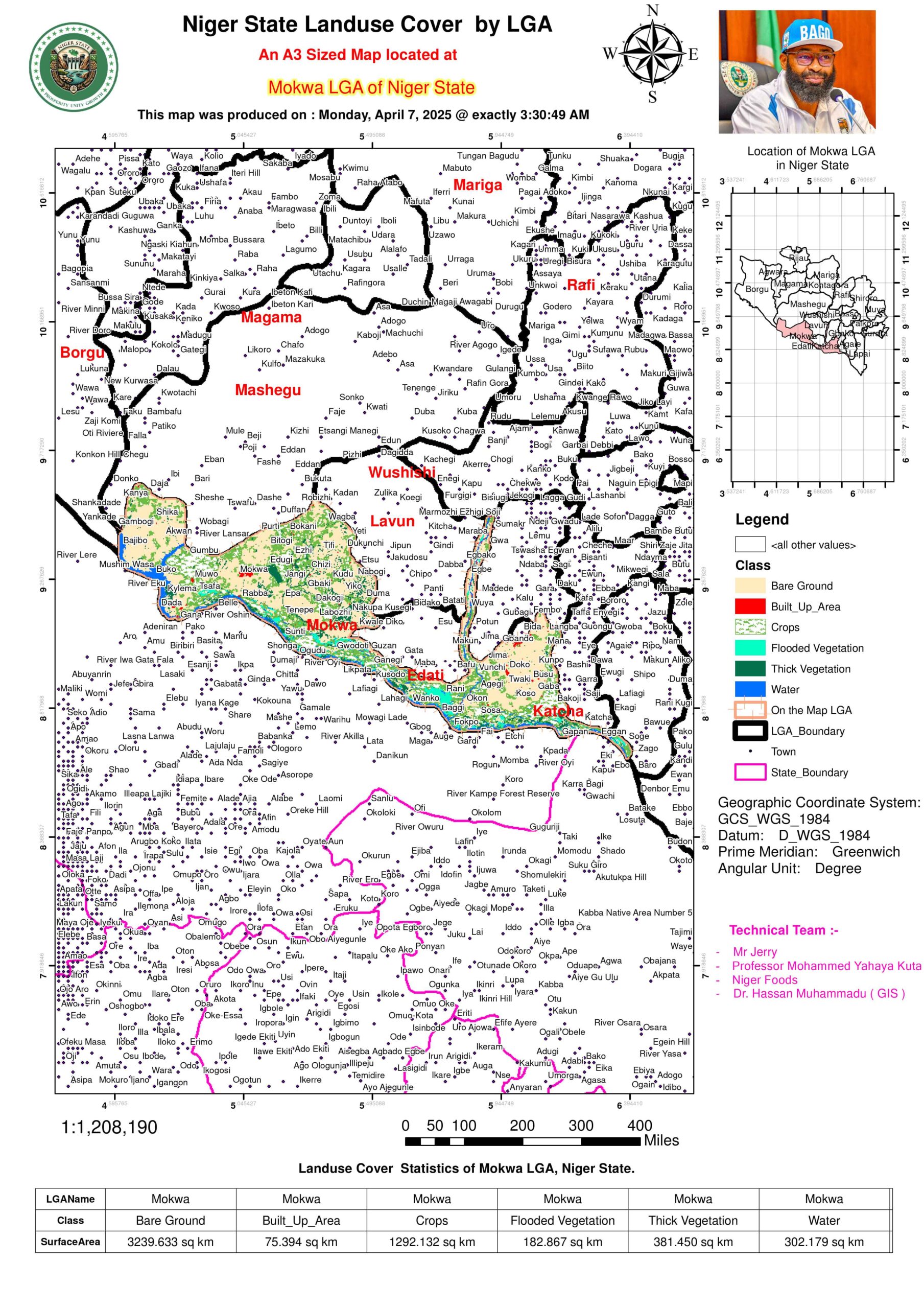
Peaks: In the region, Suleja (58.24 km²) and Mokwa (75.39 km²) exhibit higher concentrations of built-up areas, reflecting the effects of urbanization. These areas have undergone significant growth, likely due to their roles as economic hubs or their location along transit corridors. The development of infrastructure, including roads, housing, and commercial spaces, has transformed the landscape, making them key centers for trade, commerce, and population concentration.
The growth in these areas may be attributed to economic opportunities, with increased migration from rural areas seeking better employment prospects, access to services, and improved living standards. The urban expansion in these areas also indicates a shift toward more industrialized or service-oriented economies, creating a demand for better infrastructure and urban planning.
Contrast: In stark contrast, rural LGAs like Rijau (14.87 km²) show minimal urbanization, with limited built-up areas. This highlights the disparity in infrastructure development between urban and rural regions. While urban centers have seen rapid growth, rural areas often struggle with underdeveloped infrastructure, including roads, healthcare facilities, education systems, and access to clean water.
The minimal urbanization in rural LGAs such as Rijau reflects low population density, limited economic opportunities, and a dependence on agriculture for livelihood. The lack of urban growth may be due to factors such as geographic isolation, limited investment in rural development, or insufficient infrastructure that would encourage urban sprawl.
This contrast underscores a broader development gap between urban and rural areas, emphasizing the need for targeted policies and investments aimed at improving infrastructure, services, and economic opportunities in rural regions. Addressing these disparities is crucial for fostering balanced and sustainable development across the region.
3.1. Croplands: The Breadbaskets
High-Yield LGAs: Regions such as Mashegu (2,090.58 km²) and Lapai (828.07 km²) stand out as key agricultural hubs in the region, earning their designation as “breadbaskets” due to their fertile soils and access to water sources. These areas are likely home to large-scale farming activities, with crops such as maize, millet, sorghum, and cassava being staples in the region’s agricultural economy.
The abundance of arable land in Mashegu and Lapai, coupled with adequate rainfall and irrigation infrastructure, allows for the cultivation of a wide variety of crops, contributing significantly to food production and economic activities in these LGAs. The favorable environmental conditions in these areas also support crop rotation and sustainable agricultural practices, enhancing productivity and ensuring long-term soil fertility.
In addition, these areas are likely well-connected to local and regional markets, making them key players in the agricultural supply chain, further boosting their importance as food producers for both local consumption and trade.
Anomalies: On the other hand, areas like Bida (0.22 km²) and Chanchaga (0.01 km²) exhibit negligible cropland. This discrepancy can be attributed to a number of factors:
Urban Encroachment: In both Bida and Chanchaga, urbanization may have encroached on traditionally agricultural lands, converting them into residential, commercial, and industrial spaces. As urban areas expand, agricultural activities are often displaced, leading to a reduction in available cropland.
Data Granularity Issues: The very small reported cropland areas in these LGAs could also reflect challenges in data collection and granularity. These discrepancies may arise from the data resolution or how land cover types were classified, making it seem as though agricultural areas are minimal when they may be more substantial on the ground.
Overall, while Mashegu and Lapai are clear agricultural strongholds, the challenges in Bida and Chanchaga highlight the tension between urban development and agriculture that is becoming more prevalent in regions undergoing rapid population growth and industrialization.
3.2. Water Bodies: Lifelines and Risks
Major Reservoirs: The region is home to significant water bodies that play an essential role in supporting the local economy, particularly in the areas of hydropower generation and fisheries. Borgu (370.79 km²) and Shiroro (395.17 km²) are key LGAs with substantial water resources, including rivers, reservoirs, and dams.
Shiroro is particularly noteworthy due to the Shiroro Dam, which provides vital hydroelectric power to the region. This dam serves as a critical infrastructure project, not only for energy production but also for irrigation, fisheries, and water supply. It is a lifeline for both local communities and industries, supplying water for consumption and agricultural irrigation during the dry season.
Borgu similarly hosts vital water bodies, which are essential for fisheries—an important industry for local livelihoods. The presence of such water resources in Borgu contributes to food security, providing both employment and a stable source of income for fishing communities.
Both of these LGAs are critical for the regional economy, relying on the sustainable management of their water resources to support the energy sector, food production, and other economic activities.
Flood Vulnerabilities: In contrast, Mokwa (182.87 km² of flooded vegetation) faces challenges related to seasonal flooding, which can affect agricultural productivity, infrastructure, and community safety. The region’s proximity to major water bodies, such as the Niger River, places it at high risk of seasonal inundation, which may result in flooding of cultivated lands and loss of crops.
Flooding can have severe consequences for the local population, displacing communities, damaging infrastructure, and causing economic losses. Therefore, Mokwa and other flood-prone areas in the region need floodplain management strategies that include early warning systems, flood defense infrastructure, and resilient agricultural practices. Strategies such as flood-resistant crops, strategic zoning, and infrastructure improvement are vital for mitigating the impacts of seasonal flooding and protecting the livelihoods of the local population.
In the long term, climate change and increased rainfall variability are likely to exacerbate flooding risks, requiring proactive measures for flood control and sustainable land use planning in flood-prone areas like Mokwa.
4.1. Desertification vs. Afforestation
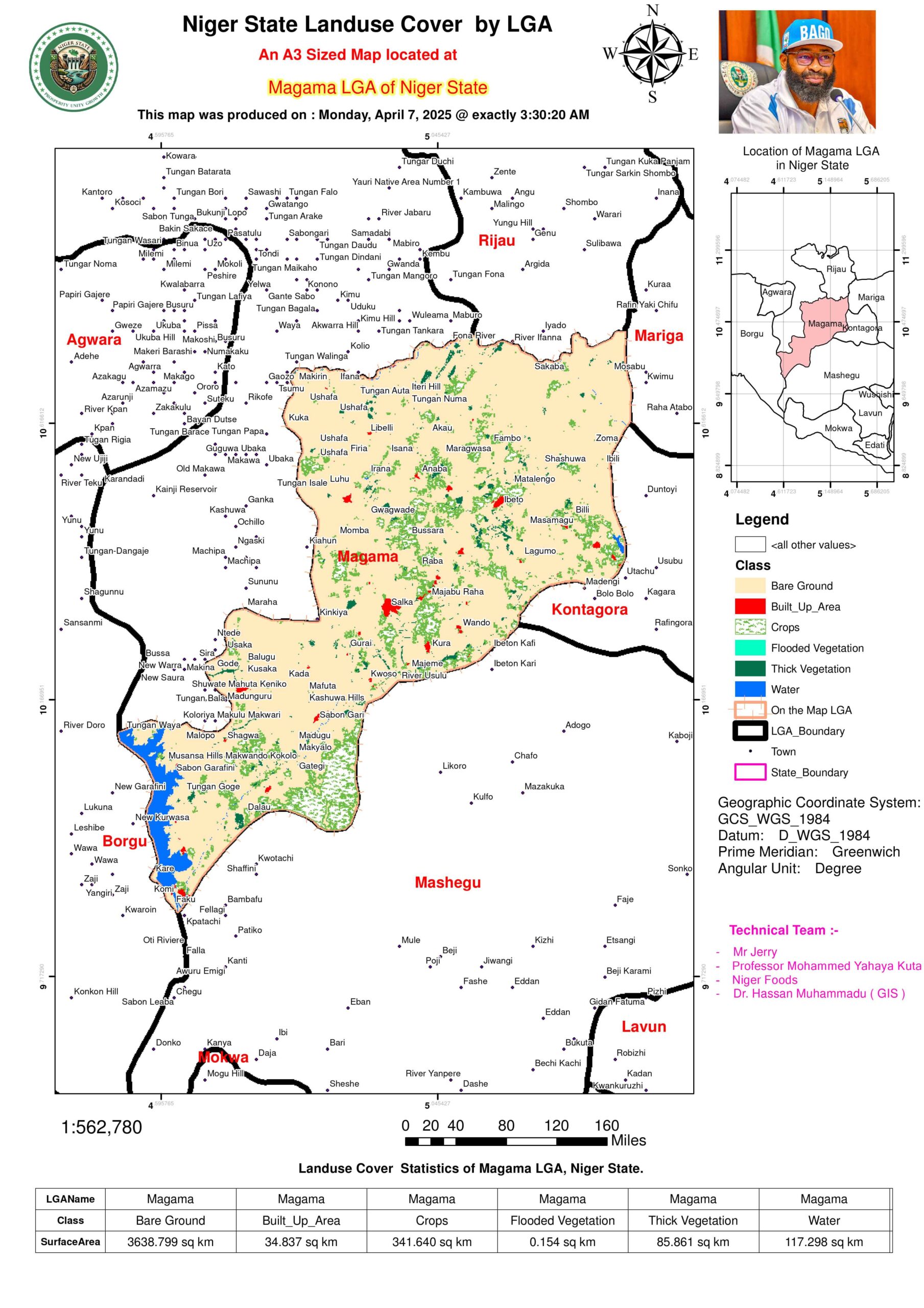
At-Risk LGAs: Regions like Magama (3,638.80 km² of bare ground) and Rafi (3,106.56 km²) are particularly vulnerable to desertification, a growing concern in the northern and semi-arid areas of Nigeria. The significant proportion of bare ground in these LGAs suggests that soil degradation, erosion, and low vegetation cover are major environmental challenges. These areas face the dual pressures of climate change and unsustainable land use practices, which contribute to the degradation of once fertile land.
Magama, with its large expanse of bare ground, is particularly susceptible to desertification, which can worsen in the face of poor vegetation cover and water scarcity. The continuous removal of vegetation for agricultural expansion or firewood collection accelerates soil erosion, depleting soil nutrients and reducing agricultural productivity. These challenges require urgent afforestation and reforestation programs to restore vegetation, improve soil health, and reverse the degradation process.
Rafi, similarly affected by land degradation, will require concerted efforts toward sustainable land management practices. Given the scale of bare ground in these regions, introducing afforestation programs that focus on planting drought-resistant tree species, promoting soil conservation techniques, and ensuring community involvement will be key in mitigating desertification.
The establishment of green belts, windbreaks, and shelterbelts would be effective strategies to reduce wind erosion and increase local rainfall retention, while also restoring biodiversity.
Success Stories: On the other hand, Lavun (383.30 km² of thick vegetation) presents a success story in natural resilience or conservation efforts. This area’s relatively high vegetation cover signals successful local conservation initiatives or natural recovery, demonstrating that ecological resilience is possible with the right balance of land management and protection.
The high density of vegetation in Lavun suggests effective management or the presence of protected forest areas, where human encroachment is limited and biodiversity thrives. Lavun could serve as a model for neighboring LGAs struggling with desertification, offering valuable lessons in sustainable land use, community-based conservation, and reforestation efforts.
In contrast to the struggles faced by Magama and Rafi, Lavun’s approach could be replicated across other regions to prevent further land degradation and to promote environmental restoration.
4.2. Urban Expansion vs. Agricultural Land
Conflict Zones: The rapid pace of urban expansion is placing increasing pressure on agricultural land across the region. A notable example is Suleja, where urban sprawl is evident in the 58.24 km² of built-up areas, while the surrounding agricultural land remains limited, with only 11.50 km² allocated for cropland. This juxtaposition highlights a growing conflict between urbanization and agriculture, as expanding cities encroach on productive farmland that is essential for food security.
Urban expansion is driven by population growth, increased economic activities, and improved infrastructure, which are beneficial in many ways but can come at the cost of agricultural land. As cities like Suleja expand, housing developments, industrial zones, and commercial establishments increasingly replace agricultural fields, leading to the reduction of arable land and a loss of food production capacity.
The competition between urban needs and agricultural land presents a challenge for land-use planning and sustainable development. Urban sprawl in Suleja and similar LGAs can lead to fragmentation of cropland, making farming operations less efficient and contributing to food insecurity. As urbanization continues, the preservation of agricultural land and the promotion of smart growth policies will become critical to ensuring a balance between development and food production.
Balancing Urban and Agricultural Needs: To address the conflict between urban expansion and agricultural land, integrated land-use planning strategies will be essential. Zoning regulations, green spaces, and the development of peri-urban farming systems could help preserve agricultural land around urban areas like Suleja. Additionally, vertical farming and urban agriculture can be promoted within cities to support food production without encroaching on farmland.
Moreover, investments in infrastructure, such as the development of efficient transport networks and market access for agricultural products, can help make urban growth more sustainable, ensuring that both urban and rural communities benefit from economic growth without compromising food security. For more details have a tour arround the 25 LGAs of the state.
