Land Suitability Maps for Feedlots and Pastures
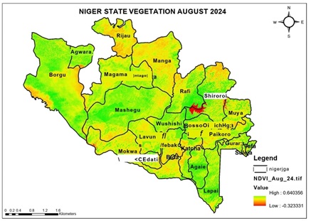
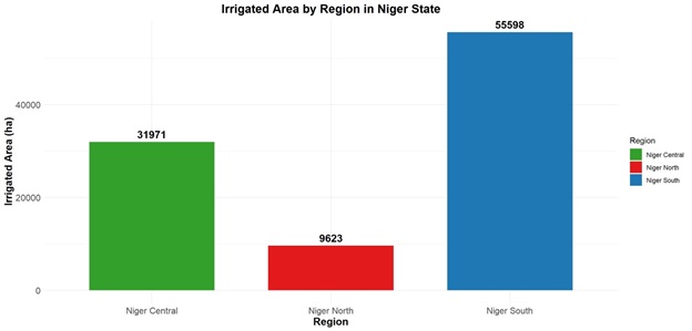
The land suitability analysis identified optimal locations for establishing feedlots and extensive pasture systems across Niger State. Using GIS tools, data on soil properties like fertility and drainage, vegetation cover (NDVI)  , Natural Drainage and flow accumulation, Slope using DEM and water availability (proximity to rivers, lakes, and groundwater) were integrated. The results revealed that 70% of the state’s arable land is suitable for cattle breeding and fattening, with the most favorable areas located in the central and southern regions, where soil fertility and water access are optimal. Flood-prone and steep areas were excluded, ensuring sustainable land use and minimizing environmental risks. The graph uses distinct colors for each region, making it easy to differentiate between them. The graph below depicts the distribution of irrigated areas across three regions in Niger State: Niger South, Niger Central, and Niger North. The y-axis represents the irrigated area in hectares (ha), while the x-axis lists the three regions. The bar heights and corresponding numerical labels indicate the total irrigated area for each region. Niger South has the largest irrigated area (55,598 ha), followed by Niger Central (31,971 ha), and Niger North has the smallest irrigated area (9,623 ha). The data reveals significant disparities in irrigated areas across the three regions. Niger South dominates with more than double the irrigated area of Niger Central and nearly six times that of Niger North. This disparity could be attributed to several factors, such as geographical features, water availability, agricultural practices, or investment in irrigation infrastructure. For instance, Niger South might have better access to water resources or more developed irrigation systems, while Niger North could face challenges like arid conditions or limited infrastructure. The graph highlights the need for targeted agricultural policies and investments to address these regional imbalances and promote equitable development.
  The data suggests opportunities for improving agricultural productivity and sustainability in Niger State. For Niger South, the focus could be on optimizing existing irrigation systems and introducing advanced agricultural technologies. Niger Central has potential for expansion, given its moderate irrigated area, and could benefit from increased investment in irrigation infrastructure. Niger North, with the smallest irrigated area, presents an opportunity for development through initiatives like water conservation projects, drought-resistant crops, and small-scale irrigation systems. Addressing these regional disparities could enhance food security, boost economic growth, and reduce poverty across Niger State. Additionally, further research into the underlying causes of these disparities could inform more effective policy interventions.